Tuesday, October 4, 2011

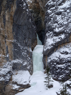
Return of my Hero.


Jason and Janice returned safely from their awesome trip to South America.  

About month after their return, Jason came over to take away his precious tools.  

I enjoyed swinging his tools, and was reluctant to return them.

I had a great season with them; 8 ice days, much improved over the last ten years or so.  Hopefully more in 2011/2012!?


Wednesday, April 6, 2011

Grotto Falls, Hers and Sketch and Sniff

(Climb date: Saturday April 2, 2011)

I was super keen to head to The Professor Falls, but Friday it snowed about 25 cm’s and during the day Saturday it snow another 25.  The avi and road conditions were crap, so Steve and I settled for an easy day at Grotto Falls.


The upper section of Grotto had grown more than normal and the upper section had a steep curtain to the left of the gully, probably 4-, it was steep.


After blasting up Grotto, brought Steve up, rapped, and then over to Hers.  His was melted out on the bottom.  Hers was fatter than normal, maybe 4-, but the upper section had very poor quality ice and it was not easy to get over the chained anchor.


Once the top rope was up, Steve and I did lap, after lap, on the left side, very delicate side, of the pillar.  We also did several laps on the mixed route, “Sketch and Sniff” (M6+); lots of fun.


Once we couldn’t use our arms anymore, we went to the Drake for pints!  Fun short day.

Tuesday, March 22, 2011

Slurpee

(Climb date: Sunday March 20, 2011)

I was hoping to lead most of the WI4 routes up near WD40 and Green Monster area before the end of this ice season, so I headed back to Evan-Thomas Creek with Rafal.


For something different, we took the approach straight up the creek when it turns into a canyon.  I haven’t gone that way since 1995 when I was first in this part of the creek with Tony Barton.  

A good trail took a high line way up the cliffs, higher than Tony and I did back in the day.  Good trail, but very narrow in sections, parts of trail had help from mini snow bridges. Arrived at WD40 much quicker.


Turns out my lack of ice climbing for about 5 weeks messed up my head space a bit.  First looked at WD40, but the quality of the ice was poor and starting to get anemic, so we headed to Green Monster.  


Once I put my nose against the steep ice (probably in grade 5 shape right now), I knew I wasn’t going up there.


We headed back downstream to Slurpee.  Walked up to the 25 metre pillar and the ice quality looked great.  The tight canyon/bowl protects this route from the strength of the spring sun and the ice was good to go!


Geared up and launched into a brisk lead, then the grovel began… 


the pillar was definitely in grade 4 shape and quite pumpy, and one had to dig a bit for screws.  Again the lack of leading ice for more than 5 weeks lowered my confidence and I had a desire to sew up the route a bit.


Bad call; the search for ice that would take a descent screw and digging for good ice started to pump me out quickly.  I had to hang dog a few times, but eventually I got my sorry ass up the route.  Poor Raf had to put up with my complaining the whole time.


Once I reach the top of the pillar, I continue up the easy last 15 metres.  My top rope anchor was at a bad angle to start, but eventually I tuned it up and Raff and I had our way with the pillar. 

After a bunch of laps, we turned the pillar into an easy peg board and called it a day.


Quick walk out and home before dark.


Saturday, February 12, 2011

Chantilly Falls, B2 & Exit Combo

(Climb date: Friday February 11, 2011)


Solo day.  Spending tomorrow recon’ing with Siddles, so I wanted to climb ice yesterday, but no other slackers had the day off to join me and I wanted to keep the ice thing going, so a solo day was in order.  Back to Evan Thomas Creek (etc), lots of good memories in this valley.


Casual hike to Chantilly Falls, guide book quotes 100 m of WI2, but I would put the final 30 at a solid grade 3 or tougher if bad ice.  Picked the steepest line on the final 20 metres, bad ice and a bit spicy for a solo for me; good fun.  Rapped off and then headed upstream to the B2, WD40 area.


Good trail to WD40 area, but a few off track trails once above the canyon on the flats.  Looks like someone climbed WD40 since the last big snow fall, about 6 days earlier. 


Solo’ed B2 twice.  First line was just left of centre, bad, technical ice with lots of air (just left of line between white and dirty ice).  


Again quite spicy for a solo for me.  Quick rap to base, picked up pack and solo’ed back up, easy far right side, then slogged up slope to exit trail.


Back to game trail, back to main creek, then headed up to Exit Combo gully.  The first little step of Exit Combo is always cool and fun, just way too short.


Cool crack in rock to right of first step, would love to mix lead it one day, looks like great trad rock gear, maybe M4, M6?


Made the very bad call of slogging up to the upper Exit Combo ice section, tough slog of knee to thigh deep snow.  Climbed upper ice, then headed to summer trail.


Holy crap, what a mistake.  Since 2008 there has been a ton of logging in this section of etc, looks like fire breaks, or maybe Pine Beetle cutting?  but there was a grid pattern of trees removed and no ski or hiking paths packed in.  Spent about one hour and about two kilometres busting knee to thigh deep snow back to etc, entered etc near the base of Moonlight, what a pain in the ass.


Despite the snow slog, had fun climbing ice, felt totally solid on all solos.

Wednesday, January 26, 2011

Brewer’s Droop

(Climb date: Sunday January 23, 2011)


Sunday Jan. 23 the Crazy Pole (Rafal) and I headed to the Sheep River to avoid the avi hazard. I had wondered about the climbs Brewer’s Droop and Betty Davis’ Sneeze for years and thought this could be a great time to check them out.

The description in Jojo’s book is bit weird and vague for the approach. Turns out there are two similar routes about 1.5 km apart. There is a grade 4 route that matches the quoted grid reference (82J/10 665119) which is at the beginning of the Sheep River Gorge, but also a grade 4 route, a 45 minute walk up the gorge (about 82J/10 641113). We climbed both routes, the farer upstream route had a pile of old sling around a tree, thus it has been climbed for sure.


It took us about two hours to ski from the road closure at Sandy McNabb to reach the confluence of the Sheep River and Gorge Creek, just west of the road Gorge Creek Trail. We walk onto the Sheep River at the big culvert that drains Gorge Creek (660127).


The steep embankment along the roadside released big slabs when we descended, scary conditions for such a minor slope, all small slopes we encountered on the walk in were crazy reactive. The Sheep River was frozen and well covered by snow, easy walking. Soon we entered the Sheep River Gorge, interesting place, we walk about 45 minutes to reach a route that looked like the description for Brewer’s Droop.


We admired the cool gorge, mostly steep dirt on the south side and very steep dirt/rock combo on the north side. We passed several ice smears on both sides of gorge on the walk in. I bet in a big ice year the gorge holds many ice lines.


The route at 641113 was a nice grade 4 route. We did it in two small pitches, solid grade 3 for about 40 metres in two steps. Final pitch of about 35 metres of solid grade 4. Exit ice was sun affected and poor quality for the final 5 metres, but the rest of the ice was great.


There was a bunch of ice visible up stream (Betty Davis’ Sneeze?), but we headed back to the 60 metre grade 4 looking ice (655119). First section of this route was steep and thin, but good ice. The final curtain was steep (4+).  We rapped off and headed home. 

Not sure which route is Brewer’s Droop, but the Sheep River gorge has plenty of ice lines, worth the simple ski in. Great day with the Crazy Pole.


Wednesday, January 19, 2011

Ghoster Coaster

(Climb date: Sunday January 16, 2011)

Sunday the Crazy Pole aka Rafal Kaz. and I climbed Ghoster Coaster. Cool route with perfect ice quality, but only one real pitch of climbing. The first ascentionists described it as a WI 3+ III 135m, but this is a real stretch. The route is close to Canmore and easy to approach with a very cool setting, a great little easy/moderate route. Sort of like a mini, mini Beowulf.

Based on the first ascent description, two full pitches of WI3 start the route.


 http://www.gravsports.com/Ice%20Pages%20Folder/Route%20Descriptions/Ghoster_Coaster.htm

We soloed most of the first “pitch”, there were both wet and dry lines, both with great ice quality. The real pitch of climbing has a beautiful solid grade 3 for about 35 metres. This must be the described 3+ pitch, the setting was awesome and the ice perfect. Once above this sweet section, the rest of the climb is basically a walk up. We did the final little step on thin ice into a thick patch of willows to finish the route and gain a view up the drainage. 

We were hoping for another step or smear higher up, but no such luck. Lots of terrain above this route with several gullies systems, but there was not enough snow to be of concern.

The sweet pitch was so much fun, we did a few laps on it.  It was grand to enjoy some warmer weather, great day.


Saturday, January 1, 2011

Haffner Creek?

(Climb date: Tuesday December 21, 2010 - Anton, Pierre and Tara?)

Lent out Jason's tool to Anton last week.  I didn't get the chance to chat with Anton when I got the tools back, but I think Anton, Pierre and Tara went to Haffner Creek?

Anton's trip report and photos to follow?

Monday, December 20, 2010

(Waxy Referendum or The Blue Door?) & King Creek

(Climb date: Sunday December 19, 2010)


Sunday Heather, Ben and I headed to Kananaskis Valley.  Both Ben and Heather were keen for some WI 3 type climbing.  I was always curious about two ice climbs along the Opal Range, on the West Face of Mt. Hood.  Jojo's ice guidebook provides two unclear route descriptions for these two routes.  One route is clearly visible from the Highway at Hood Creek.  Being visible from the highway matches with the description for Waxy Referendum, but the NTS grid reference and the approach time are off.  The K-country map in Jojo's book shows The Blue Door in the same drainage as WF.


We parked on the highway at Hood Creek and began the long slog to the ice route.  We were all concerned about the scary and steep snow slope below the route, but I was sure we could find a safe approach.  Well after 3+ hours of slogging, we all decided the snow was too scary to approach the route.  We bailed about 50 metres from the route.  I did spy another flow of grade 3 ice north of us, also on the West Face of Hood. Based on the material in Jojo's book, I think the big, blue ice route easily visible from the highway is "The Blue Door" and "Waxy Referendum" is the other route I saw.  We didn't head to the other route because of avi concerns and the complexity of terrain.  


I felt bad that we slogged in and out for about 6 or so hours, so I suggested a quick blast up and down the ice at King Creek.  So we did the short drive south to King Creek.  We arrived at the ice minutes before sunset.  We quickly gear up and I ran up a brittle 40 metres of grade 3 ish ice.  Reached the belay by headlamp and quickly brought up Heather and Ben.  Fun ice lead in the dark.  


So far J's tools are getting me out more; last ice season (2009/2010) I ice climbed twice, so far this season, I been out 3 times!


Cheers


Followers

About Me

My photo
When I started alpine climbing about 25 years I yearned to be a “hard man” alpinist. Took me awhile to understand I wasn’t cut out for that, and now, I just want to have fun.